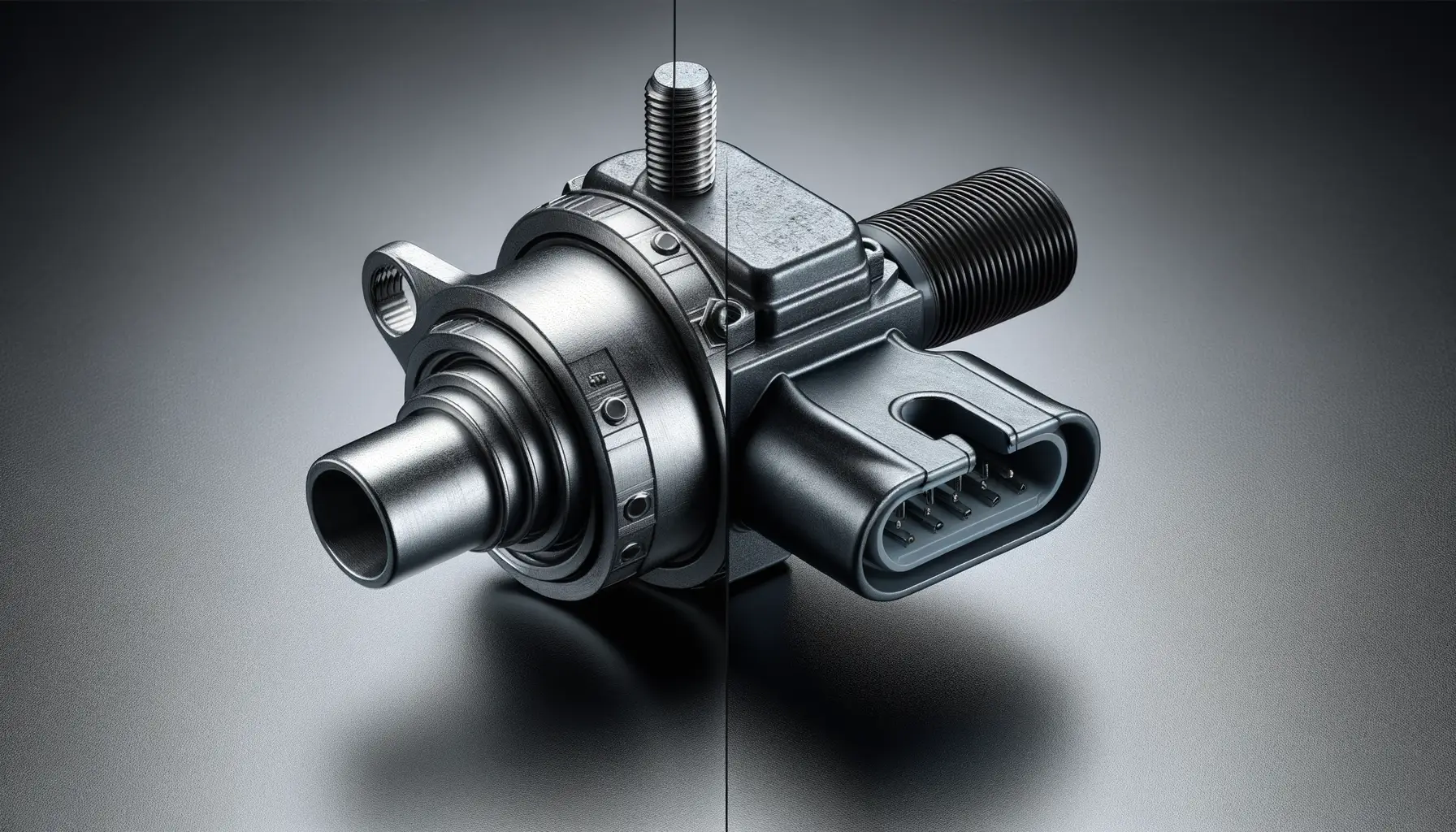
Understanding Torque Sensors in E-Mountain Bikes
What Exactly Does a Torque Sensor Do?
Imagine this – you’re climbing a steep, rugged trail on your e-mountain bike. You push harder on the pedals, and with what feels like a perfectly choreographed dance, the motor kicks in, giving you just the right amount of extra power. That seamless “dance” between your pedaling effort and motor assistance? It’s all thanks to the genius of a torque sensor.
At its core, a torque sensor measures how much force you apply when pedaling. Unlike traditional systems that rely on pedaling speed alone, it’s sensitive to your actual effort. Think of it as your bike’s way of “listening” to you—when you give more, it gives more. This intelligent response creates a natural, intuitive ride that feels almost like bionic legs.
- If you’re cruising casually, the sensor delivers gentle, precise assistance.
- But when you’re hammering uphill, it amps up the power to match your grit.
Why Riders Say It Feels Like Magic
A torque sensor doesn’t just enhance performance—it transforms it. Picture this: no jerky starts, no unnatural surges. Instead, your bike becomes an extension of your body. It reads your effort in real-time and syncs perfectly to your movements. Whether you’re navigating tight switchbacks or tackling loose gravel climbs, a torque sensor makes every pedal stroke smoother, every ride smarter, and every adventure more rewarding.
Key Benefits of Torque Sensors for Riders

Feel the Trail Like Never Before
Imagine this: you’re cruising up a steep incline, the kind that makes your legs burn just thinking about it. With a bike equipped with a torque sensor, you don’t just pedal—you whisper to your bike, and it responds. These sensors measure how hard you’re pushing on the pedals, translating your effort into seamless power assistance. The result? You feel like a superhero gliding up hills instead of slogging through them.
Beyond the climb, torque sensors deliver something even more magical—connection. They create a ride so intuitive, it’s like the bike becomes an extension of your body. The harder you push, the more support you get, blending human energy with machine precision for an unparalleled flow.
Smooth Power, Perfect Balance
When you’re out on unpredictable trails, jerky power surges are the last thing you need. Torque sensors excel at fine-tuning the electric boost, giving you a natural, steady experience. Here are just a few reasons why riders rave about them:
- Immediate response: No awkward lag or overcompensating. Just smooth acceleration exactly when you need it.
- Energy efficiency: They only assist as much as you demand, which means longer battery life for epic rides.
- Control on technical terrain: Master tricky switchbacks and root-laden paths with precise power tailored to your input.
It’s like having a riding partner who always knows what you need—before you even ask.
Comparison: Torque Sensors vs. Cadence Sensors
Feel the Power: How Torque Sensors Deliver Smarter Assistance
The difference between a torque sensor and a cadence sensor can feel like night and day when you’re tearing up mountain trails. A torque sensor reads how much pressure you’re putting into the pedals—kind of like your e-bike is tuned in to your strength and effort. It’s reactive, adaptive, and delivers power as smoothly as if it were an extension of your own legs.
In contrast, a cadence sensor acts more like an on/off switch. It knows one thing: whether you’re pedaling or not. While that’s fine for casual city cruising, it can feel clunky and imprecise when you’re navigating tricky terrain with steep climbs or sudden bursts of speed. Imagine needing a quick power boost mid-hill but your bike responds late—it’s like shouting for help and getting silence in return!
- Cadence sensors: basic, less precise, better for flat terrain or beginners.
- Torque sensors: precise, responsive, perfect for rough trails where control is king.
The Magic of Seamless Energy Flow
Riding with a torque sensor feels more natural. Your e-bike mirrors your energy output, amplifying your every move as if it’s reading your mind. Hit a technical climb, and the assistance adapts instantly; sprint downhill, and it backs off effortlessly. With a cadence sensor, the response can feel delayed or overly aggressive, leaving you wrestling with unexpected surges of power. When you’re out riding, precision matters, and that’s why torque sensors make all the difference. Would you rather feel synchronized with your bike—or like it has a mind of its own?
How Torque Sensors Enhance Trail Performance

Sensing Every Pedal Stroke
Imagine this: you’re climbing a rugged mountain trail, every twist and turn demanding precision and power. With a traditional system, you might feel a disconnect—a lag between your effort and the bike’s assist. Enter the magic of torque sensors, which revolutionize that experience by responding instantly to how much force you apply to the pedals.
It’s like the bike is reading your mind, syncing its motor’s output seamlessly with your own strength. Push harder, and the motor amps up; ease off, and the assistance dials down. The result? A perfectly balanced ride where every ounce of energy you exert matters.
- No more awkward bursts of acceleration on tight corners.
- No sudden loss of support on steep climbs.
- Just smooth, predictable power that lets you focus on the terrain ahead.
Confidence in Every Terrain
On gnarly descents or loose gravel, the responsive nature of torque-based systems keeps you grounded (literally). They allow for finesse—giving you just enough assist to maintain traction without overpowering your ride. This means better control, tighter handling, and a feeling of mastery over nature’s toughest challenges.
Whether you’re carving through switchbacks or tackling rock gardens, torque sensors elevate your performance from good to absolutely epic. It’s not just a ride; it’s a partnership between you and your bike—one that inspires limitless confidence on any trail.
Future Innovations in E-Bike Sensor Technology

Revolutionizing Ride Feedback with Advanced Sensors
Imagine your e-mountain bike becoming as intuitive as a seasoned trail guide. That’s the vision for future sensor technology. Tomorrow’s sensors will dive deeper into measuring not just torque but also environmental factors, rider posture, and even terrain types. How? Think of it like adding a sixth sense to your bike—it “feels” the trail as much as you do.
With upcoming advancements, we might soon see gyroscopic sensors paired with torque systems to respond in real-time to steep inclines or unexpected twists. Ever hit a patch of loose gravel and wish your bike could ease up or grip tighter automatically? This could become a reality.
- Smart resistance systems: Dynamically adjust pedal power on uneven surfaces.
- AI-assisted fine-tuning: The more you ride, the smarter your bike becomes—learning your pedaling style and optimizing for efficiency.
The Role of Connectivity in Tomorrow’s E-Bikes
Now take that fine-tuned magic and plug it into an app. Future bikes won’t just ride—they’ll chat with you. Picture your bike analyzing trail conditions ahead via GPS or syncing its sensors with wearable devices to track fatigue or performance. You could receive personalized ride recommendations or even tips mid-trail.
The fusion of machine learning with sensor tech is where things get truly electrifying. Forget preset modes—your bike could custom-create them for every ride. It’s like having a coach whispering insights straight through the handlebars.